DHBW Mannheim
The original in dual studies
- DHBW Mannheim
- Contact
- Campus and Directions
Main campus and satellite sites of the DHBW Mannheim
The DHBW Mannheim consists of a main campus in the district of Neuostheim, a satellite site in the district of Wohlgelegen and another satellite site in Eppelheim. The main campus is home to the rectorate, the administration, all central facilities and the majority of the courses of study. Other courses are accommodated at the satellite sites.
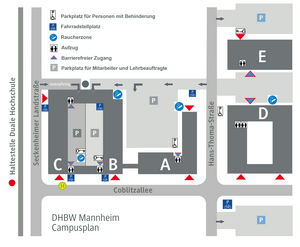
Campus Coblitzallee Neuostheim
By car: Coming from the north, leave the A6 at the Mannheim motorway junction and change to the A656 towards Mannheim-Mitte/MA-Neckarau/Flughafen. Leave the A656 at the MA-Neckarau junction towards Flughafen/MA-Neuostheim and take the B38a. After a few meters you will reach a set of traffic lights. Turn right here. Turn right again at the next set of traffic lights. The DHBW Mannheim is located approximately 600 m past the lights.
By public transport: The campus can easily be reached by public transport. From Mannheim main station, take the RNV 5 tram towards Heidelberg and alight at the "Duale Hochschule" stop. Timetable information can be obtained from Verkehrsverbund Rhein-Neckar.
Two free car parks are available to students at Campus Coblitzallee. These are located next to buildings D and E. There is also the Seckenheimer Landstraße multi-storey car park, which can be reached via the entrance between building C and the Aldi car park.
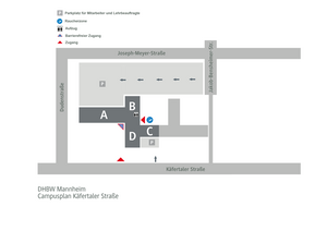
Käfertaler Straße satellite site
By car: Coming from the north, leave the A6 at Viernheimer Kreuz and change to the A659 towards MA-Käfertal. After a few meters the A659 becomes the B38. Follow the B38 for approx. 6 km until you reach Friedrich-Ebert-Straße. Turn right directly below the bridge and follow the road for approx. 400 m. Turn right into Zielstraße at the next junction. Follow the road for approx. 500 m. You will find the satellite site on the left-hand side at the corner of Dudenstraße.
By public transport: The satellite site can be reached in approx. 6 minutes from the tram stop "Exerzierplatz". From Mannheim main station take the tram RNV 5A towards Heddesheim or RNV 5 towards Weinheim. Timetable information can be obtained from Verkehrsverbund Rhein-Neckar.
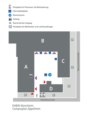
Eppelheim satellite site
By car: Coming from the north, follow the A656 towards Heidelberg. Leave the A656 at the HD-Wieblingen/HD-Pfaffengrund/Eppelheim/Edingen-Neckarhausen exit. After 350 m, turn right onto the L637. Continue towards Kurpfalzring and after approx. 600 m take the 2nd exit to the right onto Friedrich-Schott-Straße. Then turn right again into Schubertstraße and follow it for 550 m until you turn right again into Seestraße. After 170 m turn left into Handelsstraße. The Eppelheim site is on the left-hand side.
By public transport: We recommend travelling via Heidelberg main station. From here you can reach the tram stop "Bahnstadt, Hauptbahnhof Süd" on foot. From there, take the tram RNV 22 towards Eppelheim, Kirchheimer Straße and alight at the stop "Eppelheim, Rathaus". The DHBW satellite site is approx. 12 minutes' walk from here. Timetable information can be obtained from Verkehrsverbund Rhein-Neckar.


